| U.S. Weather Satellites | |||||||||||
|
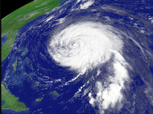
Geostationary Operational Environmental Satellites GOES satellites fly 22,300 miles above Earth from where they peer down continuously on their assigned areas of North America. These stationary satellites actually are moving in equatorial orbits so far above the planet's surface they seem to us to be standing still. Two GOES satellites send a continuous stream of weather data and visible and infrared pictures to the National Weather Service. Each can focus on a narrow or wide area and maneuver in space to obtain maximum coverage. goes web site »» goes facts »»
|
Polar Operational Environmental Satellite POES satellites fly in polar orbits 518 miles above Earth from where they look down on our planet's entire surface, passing above the North and South poles several times a day. As a polar-orbiting satellite loops around the globe, Earth seems to rotate underneath the orbit. The POES satellites offer daily coverage of the entire globe, with morning and afternoon orbits that deliver global data for weather forecasting. POES satellites reveal cloud cover, location of storms, temperatures, and the heat balance in Earth's atmosphere. poes web site »» poes facts »»
|
Defense Meteorological Satellite Program DMSP is a fleet of satellites monitoring the weather and oceans on Earth, as well as the Sun-Earth space environment, for the Air Force Space and Missile Systems Center in the Department of Defense. dmsp web site »»
|
National Polar-orbiting Operational Environmental Satellite System Prior to 1994, the U.S. government maintained two operational weather satellite systems – civilian and military. Then NPOESS was established to merge the National Oceanic and Atmospheric Administration (NOAA), National Aeronautics and Space Administration (NASA), and U.S. Air Force polar-orbiting weather satellites into one integrated national program. NPOESS satellites in low-Earth polar orbits are used to monitor global weather, atmosphere, oceans, land and space environment conditions. npoess web site »»
|
||||||||

| Backgrounders: | GOES | POES | NPOESS | Environmental Sats | Sat Data | National Weather Service | Weather Radio |
| Cover | Rockets | Satellites | Shuttles | Stations | Astronauts | Solar System | Deep Space | History | Global Links |
Search STO STO Cover E-Mail Copyright 2004 Space Today Online