Spacecraft sent home 240,000 spectacular pictures:
Mars Global Surveyor Mapped the Red Planet
After snapping more than 240,000 detailed pictures of the Red Planet over a decade, Mars Global Surveyor stopped working November 2, 2006, when a problem developed in a motor trying to swing one of its electricity-generating solar panels to track the Sun.
Digitally enhanced and enlarged image of Earth from Mars
NASA, JPL/Malin Space Science Systems
[click to enlarge]
Now, ground controllers at NASA's Jet Propulsion Laboratory in Pasadena, California, hear nothing from the spacecraft.
A sterling record. Mars Global Surveyor is lost in the orbit 234 miles above Mars from where it recorded high-resolution images of the surface and studied the climate.An inspiring story. MGS had been an inspiring story as NASA recovered from a major Mars exploration failure back in 1993. The Mars Observer spacecraft had been lost just before arriving at the planet. New versions of most of that probe's instruments were built for the MGS, which was launched November 7, 1996.
- MGS cameras were the first to record topographic features that suggested water once flowed on the surface of Mars.
- It revealed Mars once had a magnetic field when its magnetometer detected the remains of a field that once had shielded Mars' surface from deadly cosmic rays.
- Pictures sent home by MGS gave scientists back on Earth their first look at massive dust storms and gullies on the Red Planet.
- Its maps of minerals on the surface were used by NASA scientists to select landing sites for the twin Mars exploration rovers Sprit and Opportunity.
- Its maps also were used to evaluate landing sites for the next-generation of Mars landers, Phoenix landing in 2008 and the Mars Science Laboratory in 2010.
At the time of its demise, Mars Global Surveyor was the oldest of five NASA robot explorers studying Mars among six active space probes either circling or landed on the Red Planet. Three satellites still are at work in orbit above the planet – Mars Odyssey, Mars Reconnaissance Orbiter and Europe's Mars Express – while the landers Spirit and Opportunity rove around the surface below.
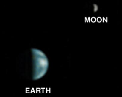
The original story. Mars Global Surveyor has been orbiting the Red Planet since 1997, sending back reams of spectacular photos. Now the MGS spacecraft has snapped the first ever picture of our own home planet taken from a another planet.
In the unique 2003 photo from around 35 million miles away, half of Earth's disk appears as a tiny world in an ocean of darkness in space.
The image, at right, of what NASA calls a "half-Earth phase" was processed by computer software so both Earth and the Moon become visible. Computer operators on Earth added the wire frame around our planet, at far right, to show the relative positions of North and South America. [how the image was colorized]
Because Earth and the Moon are closer to the Sun than to Mars, they exhibit phases, just as the Moon, Venus and Mercury do when viewed from Earth.
The bright area at the top of the Earth image is cloud cover over central and eastern North America. Central America and the Gulf of Mexico are in the darker area.
Clouds over northern South America compose a bright spot near the center-right of the crescent Earth.
The Earth and the Moon image shows the hemisphere of the Moon that faces Earth, since the Moon was on the far side of Earth when viewed from Mars.
The brighter area at the bottom of the Moon image is a system of large, conspicuous rays emanating from the Tycho crater. nasa mars global surveyor home page
NASA had tried to use its Pathfinder lander on Mars to snap a photo of Earth back in 1997-1998, but cloudy skies over Mars prevented it.
The Mars Global Surveyor picture was recorded on May 8, 2003, at 13:00 UTC. coordinated universal time
The orbiting Mars Global Surveyor has photographed landers on the surface of Mars:
Viking 2 »» Mars Polar Lander »» Mars rover Opportunity »» Mars rover Spirit »»
STO story about Viking 2 »» STO story about Mars Polar Lander »» STO story about the Mars rovers »»
Malin Space Science Systems (MSSS) of San Diego, California, operates the camera aboard MGS for NASA.
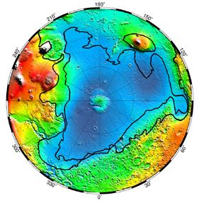
Mars Global Surveyor map of the ancient oceans on Mars. [click to enlarge]
A treasure trove. Mars Global Surveyor has been orbiting the Red Planet since September 12, 1997. The spacecraft has examined the entire Martian surface and provided a wealth of information about the planet's atmosphere and interior.
In fact, Mars Global Surveyor has returned more data about the Red Planet than all other Mars missions combined.
Evaluation of landing sites for two Mars Exploration Rovers in 2003 relied heavily on mineral mapping, detailed imagery and topographic measurements made by Global Surveyor.
Launch to Mars
Mars Global Surveyor was launched November 7, 1996, from Cape Canaveral, Florida. It arrived in orbit around Mars ten months later to begin surveying and mapping the Red Planet from orbit in March 1998.
Meanwhile, NASA's Mars Pathfinder spacecraft, which left Earth a month after Mars Global Surveyor, passed the Global Surveyor enroute to Mars on March 14, 1997. Pathfinder landed on Mars on July 4, 1997.
At 2,342 lbs., the Global Surveyor is about the size and weight of a Plymouth Neon automobile.
Arrival at Mars
As it approched Mars, Global Surveyor used rocket propulsion to enter Martian orbit and then aerobraking to descend to its operational altitude. Global Surveyor aerobraked safely into its final orbit around Mars despite suffering one partially deployed solar panel.
The critical maneuver began upon arrival at Mars with a 22-minute main rocket engine burn that slowed the Global Surveyor spacecraft to about 9,000 mph (14,400 kph) and placed it into an elliptical orbit.
Orbiting in the sky. NASA's Mars Global Surveyor spacecraft successfully entered the Martian orbit September 11, 1997, after a 308-day, 466-million-mile trip.
Unlike the Mars Pathfinder lander, Global Surveyor didn't drop down to the surface of Mars. Instead, it remains high overhead, in orbit around the Red Planet, photographing the planet surface.
During its first four months at Mars, Global Surveyor reshaped its orbit 235 miles above the Red Planet. Then, for one Martian year (687 Earth days), Global Surveyor snaps high-resolution photos of the planet. Its goal is to map the entire Martian globe, laying the foundation for 10 more years of NASA missions.
Global Surveyor's role is to determine the geology and perhaps the past history of Mars and its climate. It is designed to compile global maps of Mars and collect data on its atmosphere, surface composition, interior and evolution.
Aerobraking
Tested first by the Magellan spacecraft at Venus in October 1994, aerobraking allows an interplanetary probe to carry less fuel to a planet and take advantage of the planet's atmospheric drag to descend to a low-altitude orbit.
Mars Global Surveyor used an aerobraking phase much like that used to circularize Magellan's orbit. The Global Surveyor's solar wings -- with a "Kapton flap" at the tip of each panel for added drag -- supplied most of the surface area that slowed the spacecraft by more than 2,684 miles per hour during the four-month aerobraking phase. Global Surveyor's orbit around Mars shrank from an initial, highly elliptical orbit of 45 hours to a nearly circular orbit taking less than two hours to complete.
Stuck Solar Panel
The stuck solar panel is one of two eleven-foot wings unfolded after launch. Telemetry data transmitted from Global Surveyor suggested a piece of metal -- known as a "damper arm" and part of an opening mechanism located at an "elbow joint" where the entire solar panel is attached to the spacecraft body -- may have been sheared off during opening in the first day of flight from Earth. A lever that turns a shaft became wedged in a two-inch space between the shoulder joint and the edge of the solar panel, leaving the panel tilted at 20.5 degrees from its fully deployed and latched position.
Although the problem didn't threaten the mission's scientific plans, the tilted solar array caused a re-evaluation of aerobraking in which the spacecraft relys on its solar panels for the drag needed to lower it into a circular mapping orbit over the poles of the Red Planet. The four-month aerobraking phase of the flight began a week after Global Surveyor was captured in orbit around Mars.
Over four months, Global Surveyor used a navigational technique called aerobraking which relied on the friction of Mars' atmosphere to trim the orbit to a near-circle 234 miles above the planet for the beginning of a year (two Earth years) of science operations above Mars.
Thanks to an early launch which put the spacecraft into an advantageous trajectory, Global Surveyor did not have to aerobrake into the Martian atmosphere as fast as originally planned to reach the mapping orbit. That reduced the amount of heating that the solar panels underwent during the gradual descent.
Engineers rotated the solar-cell side of the panel that was not fully deployed by 180 degrees, so that it faced into the direction of the air flow that exerts drag force on the spacecraft as it dips repeatedly into the atmosphere. That way, the unlatched panel would not be in danger of folding up onto the spacecraft's main structure, nor would the panel be at any greater risk of heating up too much.
When engineers back home on Earth determined that the deployment springs currently holding the tilted solar panel in its not-quite-deployed position would not be strong enough to withstand the forces of aerobraking, they designed a new configuration in which the tilted solar panel, along with the deployment springs, would be rotated 180 degrees, using a motor-driven inner gimbal actuator, and held in position with force applied by an outer gimbal actuator.
Sequencing software will be modified to turn the gimbal actuators on before each closest approach to the planet and off at the conclusion of each drag pass. Thus, the more sensitive solar-cell-side of the unlatched wing will be exposed directly to the wind flow of atmospheric entry, requiring that aerobraking be done in a more gradual, gentle manner.
The rest of Global Surveyor's equipment performed very well on its arcing flight path to the Red Planet.
Baseball Toss
Global Surveyor flew what flight engineers called a "perfect course" to rendezvous with Mars. A NASA project manager said the engineers were "threading the needle" as they navigated the spacecraft through space.
Having Global Surveyor enter orbit properly after a 435-million-mile jaunt through space, the project manager said, was like tossing a baseball from NASA's Jet Propulsion Laboratory in Pasadena, California, and hitting a specific window in the Empire State building in New York City.
Lake Shores and Ancient Hot Springs
Starting in March 1998, Global Surveyor makes pole-to-pole observations that will be the foundation for future exploration maps.Global Surveyor is bigger and not as dramatic as Pathfinder. It won't land on the planet surface like Pathfinder. It won't be able to find definitive evidence of life on Mars. It won't accomplish its mission until the beginning of the century. However, Global Surveyor's findings will be every bit as valuable as Pathfinder.
From above, Global Surveyor will be able to identify the likeliest sites where life might have taken hold on the planet in ancient times. Those include areas where there once was water, such as lake shores and mineral remains of ancient hot springs.
Global Surveyor is designed to carry out 75 percent of the work planned for the ill-fated, $980 million Mars Observer which disappeared three days before it was supposed to reach the Red Planet in August 1993. By comparison, Global Surveyor cost only $135 million dollars.
NASA scientists think Mars Observer's propulsion system failed, blasting the spacecraft past Mars into an orbit around the Sun. Global Surveyor carries the same scientific equipment as Mars Observer and many of the earlier craft's spare parts.
Global Surveyor has the same objectives as Mars Observer. Global Surveyor was designed to:Global Surveyor has a battery of cameras to photograph the entire Martian globe. The pictures will create a portrait of the planet's topography and mineral composition.
- Compile global maps of the entire planet,
- Return high-resolution pictures of the planet's surface,
- Collect data on the Martian atmosphere, magnetic properties, mineral composition, interior and evolution.
The spacecraft's on-board sensors can detect the presence of water in the atmosphere.
Once its science mission has been completed, Global Surveyor will remain in Martian orbit as a communications satellite, relaying signals from other landers and probes for three more years.
The Global Surveyor mission inaugurates a new series of Mars expeditions in which NASA will launch pairs of landers and orbiters to Mars every 26 months into the next decade.


