| SPACE TODAY ONLINE COVERING SPACE FROM EARTH TO THE EDGE OF THE UNIVERSE | ||||||||||
| COVER | SOLAR SYSTEM | DEEP SPACE | SHUTTLES | STATIONS | ASTRONAUTS | SATELLITES | ROCKETS | HISTORY | GLOBAL LINKS | SEARCH |
U.S. global positioning satellites:NAVSTAR GPS

The fleet of NAVSTAR global positioning system (GPS) satellites provides latitude, longitude, altitude, direction of travel, travel velocity and correct time of day to anyone anywhere, day or night, in any weather.
NAVSTAR is short for Navigation System using Timing And Ranging.
Design of the United States' extensive 24-satellite system was authorized in 1973 and the first satellite was launched in 1978.
The U.S. Air Force created the constellation of NAVSTAR satellites circling Earth twice a day. At least four of the space beacons are in view from any spot on Earth at any time.
New deal. Just as America's earlier satellite navigation system known as Transit gave more-precise location fixes than the Loran non-satellite navigation system on the ground, NAVSTAR gives more-precise location fixes more frequently than Transit.
Where the older generations of American navigation satellites had flown only 600 miles above Earth, NAVSTARs are sent much higher to 12,625 miles above Earth.
Transit satellites transmitted on two frequencies, at 150 and 400 MHz. NAVSTARs transmit on two. But NAVSTAR's frequencies are much higher, with 1575.42 MHz for civilians and 1227.60 MHz for military services.
Where the older system used six satellites in orbit, NAVSTAR uses 24 satellites flying in six rings of four satellites. Among the 24, three are working spares stored in orbit.
In the old system, the time between bearings was 90-110 minutes. In the NAVSTAR scheme, any point on Earth is in view of several satellites at all times so bearings can be computed instantaneously whenever desired.
Ships, planes, trains, trucks, cars and even persons on foot can know their positions in latitude, longitude, and altitude within 58 feet or 328 feet anywhere in any weather, along with their velocity within 0.45 mph, or better than one foot per second, and correct time to within one-millionth of a second.
System. The NAVSTAR system consists of a constellation of orbiting satellites, a ground control system, and thousands of GPS receivers in use on the ground and in the air.
A receiver on the ground has to hear from only three NAVSTAR satellites to find its own latitude and longitude location. Hearing from a fourth satellite lets the receiver calculate its own altitude.
Military. NAVSTAR is a Defense Department project. The NAVSTAR Control Center is at the U.S. Air Force space command, Falcon Air Force Base, Colorado Springs, Colorado.
Air Force receivers around the globe monitor all NAVSTARs for the Colorado Springs master control station, which updates each satellite's navigation and health messages for all users.
Each satellite also monitors its own navigation data errors, signal availability, anti-spoof failures and clock failures. If something fails, users are notified within six seconds. Some failures are reported only to master control and can take from 15 minutes to several hours to rectify.
Gulf War. U.S. and Allied military forces in Operation Desert Storm during the Persian Gulf War in 1991 were the first to make extensive use of NAVSTARs in combat. On land, sea and in the air, they received global, three-dimensional, position and speed information.
Forces could observe voice and radar radio silence during a rendezvous. Aircraft could link up for mid-air refueling without communications.
F-16 fighter planes and B-52 bombers used GPS receivers to deliver bombs and guided munitions on specified military targets. Navy cruise missiles used GPS position data to attack heavily defended high-priority targets. The Army had GPS receivers in Apache helicopters and M60 tanks.
Army and Marine troops followed their hand-held GPS receivers across the featureless Saudi desert. GPS was used to site radar, while forward observers used GPS to direct artillery fire on Iraqi positions. The Navy used GPS to map mine fields and to direct the rendezvous of supply ships.
Somalia. In Operation Restore Hope in Somalia in 1992-93, GPS receivers were aboard Air Force and civilian cargo aircraft for approaching and landing at makeshift airfields without the electronic aids available at most larger airports.
Yugoslavia and Afghanistan. GPS receivers were used by all arms of the military during the Yugoslav and Afghan conflicts in 1999 and 2001. SATELLITE WARS
Civilian uses. NAVSTAR receivers guide planes, ships, trucks, buses, spacecraft and even private automobiles. Myriad applications include mapping, aerial refueling rendezvous, geodetic surveys and oceanography, law enforcement and fire fighting, air traffic control, space operations, exploring off-shore for oil, and search and rescue.
Nearly all land surveying today uses GPS receivers and NAVSTAR is being used to measure Earth movement along geological faults.
Receivers are so small and inexpensive that hikers are packing handheld personal navigators weighing under a pound into the wilderness.
Recreational use of GPS by boat owners is expanding rapidly. Receivers in private planes are permitting touch downs in the dark.
Dispatchers track GPS-equipped police, fire and rescue vehicles continuously on computer maps.
Refrigerated railcars and uranium shipments are tracked across the nation. Truck, train and ship terminal bottlenecks are relieved as dispatchers know ahead of time who is coming and when.
For instance, Dallas monitors its bus fleet with GPS, while a Louisiana, dispatcher uses a GPS vehicle locator to follow Lafayette's ambulance fleet through 22 southern Louisiana parishes and Baton Rouge on one electronic map.
The Coast Guard uses real-time differential GPS to navigate harbors. Using NAVSTAR for harbor and ship navigation reduces oil tanker accidents.
Robots. Engineers are predicting that all ships, planes, trucks, buses and automobiles will have GPS receivers very soon. Boats on inland waterways avoid collisions with a warning device built around NAVSTAR. Downed aircraft and boats lost at sea are located quickly as they transmit GPS position data to search parties.
Robot crop dusting aircraft will follow location information from NAVSTAR. Road grading will be done by robot equipment operators using NAVSTAR positions to move about.
Eventually, robots will do land surveys. Map making and wild-animal tracking today are completed by machines following NAVSTAR data. Ocean buoys monitor themselves, while air traffic control becomes more automatic.
Highway maps. Ohio State University invented a time-saving, money-saving use for GPS satellites in 1991, with a machine to check on highway deterioration for the Federal Highway Administration, the transportation departments of 38 states, and the Canadian province of Alberta.
The university's Center for Mapping mounted TV cameras and GPS receivers on a van to cruise secondary roads, cross bridges, and pass equipment sites, grass-mowing areas and railway crossings.
As the high-tech truck rolled along highways, its cameras scanned the terrain for roadways needing repair, hazardous conditions and locations of fatal accidents, while the receivers recorded latitude and longitude. Results were stored as digital maps in a Geographic Information System computer.
The GPS van was tested on roads in Louisiana, Ohio, Florida, Colorado, Virginia, and the West Coast. Unreported road deterioration costs the United States billions each year in wasted fuel and vehicle repairs. As a bonus, states have been able to use the digital data to draw new road maps for motorists.
The Center showed how to use GPS to manage land, ocean resources and erosion, and help relieve disasters.
Blocks. From 1973, the Air Force Space and Missile Systems Center at Los Angeles Air Force Base and Rockwell International Corp. designed and tested eleven, developmental, solar-powered NAVSTAR satellites.
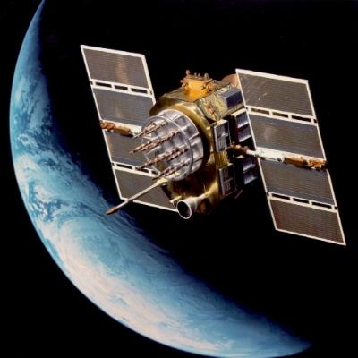
USAF Research Laboratory artist concept of
NAVSTAR GPS above Earth
First-generation NAVSTARs were called block 1, while the second-generation were known as block 2. Launch of eleven block-1 NAVSTARs from Vandenberg began with NAVSTAR-1 on February 22, 1978.
In 1983, the Pentagon ordered 28 improved second-generation NAVSTARs from Rockwell. Block-2 satellites would include 21 working in orbit, 3 working spares in orbit, and 4 replenishment spares on the ground to be launched as needed to replace aging satellites.
The first block-2 NAVSTAR went to orbit February 14, 1989, on a Delta rocket from Cape Canaveral Air Force Station. Use of a Delta rocket resulted when loss of shuttle Challenger in 1986 grounded the American fleet nearly three years. With no way to send payloads to orbit, the Pentagon rushed to buy 21 Deltas from McDonnell Douglas Space Systems of California.
After nine block-2 satellites were fired to orbit, refinements were made and the Air Force started launching block-2a satellites to space in 1990.
Six block-2a NAVSTARs were launched in 1992 and again in 1993. In 35 years of American space satellite history to that time, that was the most of any one kind of satellite sent to space in multiple launches in one year. More NAVSTARs have been launched in later years.
Identity. Since all NAVSTARs transmit on the same frequency, they are distinguished by their pseudo random noise (PRN) number.
Contents. Each satellite transmits a continuous stream of data, telling where it is at a given moment and what time it is at that moment.
Navigation data includes satellite ephemeris and atmospheric propagation corrections. System information includes clock bias.
A NAVSTAR also relays information about nearby satellites. In effect, it is transmitting a periodically-updated celestial almanac and a receiver on the ground is holding that data in memory.
NAVSTAR satellites also carry sensors for detecting nuclear explosions.
Shorting civilians. At the outset, the Pentagon intentionally reduced dramatically the accuracy of NAVSTAR GPS data available to civilians.
NAVSTAR satellites offered Precise Positioning Service (PPS) for military units and Standard Positioning Service (SPS) for civilians.
PPS gives horizontal positions accurate to within 58 feet and vertical positions to within 91 feet. SPS gives horizontal positions accurate to within 328 feet and vertical to within 512 feet.
Signals are sent from NAVSTAR satellites in codes and must be decoded by a GPS receiver. The codes are precise (P) and coarse/acquisition (C/A).
P-coded signals are available only for use by military forces, while the C/A code has been publicized so it can be used by civilians.
The C/A signal allows calculation of position to within 328 feet. The P signal offers far-more-accurate computation of position to within 58 feet.
Each GPS satellite broadcasts spread-spectrum signals on two L-band frequencies, known as channels L1 and L2. Channel L1 carries both P and C/A signals at 1575.42 MHz. Channel L2 transmits only P-coded signals at 1227.60 MHz.
Responding to civilians. Under pressure from civilian organizations, U.S. President William J. Clinton in May 2000 ordered the selective availability function turned off. C/A codes then became far more precise.
However, U.S. President George W. Bush in 2004 established plans for temporarily disabling GPS satellites during future national crises to prevent terrorists from using the navigational technology.
Using a receiver. Despite the military heritage of the NAVSTAR system, handheld and mobile GPS receivers giving locations in latitude and longitude are sold to civilians by stores and catalog merchants around the world.
When a user turns his receiver on, it starts searching the airwaves for signals from the closest satellite. Finding a satellite, the receiver accepts almanac data and records it in memory.
Next, the receiver listens to three nearby satellites for their positions and time signals. A fourth satellite is received for a reference time.
The receiver checks its clock to see when it received a time signal. It compares its time with the time reported by a satellite to see how long it took the radio signal to get to it from the satellite.
Using the known speed of radio signals, the receiver calculates the distance to the satellite. From the distance to three satellites, the receiver can triangulate or fix its position accurately.2-D. Boats on water and other slow-moving vehicles not requiring altitude fixes can triangulate with only three satellites. With three satellites, the fix is two-dimensional.
Satnav. NAVSTAR enhanced the services provided by previous satellite systems, bringing greater accuracy at lower cost.
3-D. Altitude or height above Earth's surface is the missing third dimension. For altitude, data must be received from a fourth satellite.
Of course, Transit "Satnav" receivers still are used to obtain data from those older satellites still in orbit. Satnav receivers still rely on a satellite passing overhead every 90 minutes for a new position fix, while NAVSTAR provides instantaneous data in three dimensions.
Speed. A GPS satellite sends down two kinds of data -- time-location and celestial almanac. GPS receivers are separated into single-channel, 2-channel, 5-channel, up to 20-channel types, depending on amount of data received at one time.
A single-channel receiver takes in either time-location data or celestial-almanac data from one satellite at a time, leading to slower computations.
A two-channel receiver takes in time-location data and celestial-almanac data at the same time from one satellite. That lets it calculate faster.
A single-channel receiver takes ten to fifteen seconds to fix its position, while a two-channel receiver updates its position twice in one second.
Professional receivers used by surveyors and others are five-channel receivers. Four of the channels listen for time-and-place data from four satellites, while a fifth channel listens to celestial almanac data from one satellite. Position fixes from a five-channel receiver are extraordinarily accurate and updated many times each second.
Learn more: NAVSTAR Global Positioning System STO U.S. Coast Guard Navigation Center NAVSTAR GPS Operations U.S.Naval Observatory GPS Timing Operations U.S.Naval Observatory Global Positioning System Overview Univ of Colorado NAVSTAR GPS Fact Sheet U.S.Air Force GPS Garmin What is DGPS? National Geodetic Survey NOAA How GPS Receivers Work How Stuff Works GPS Internet Information Resources
GPS Used to Track Birds STO Satellites Track Threatened Birds and Animals STO Satellite Wars Over Afghanistan and Yugoslavia STO Galileo STO Galileo Europa Galileo ESA Galileo Industries Galileo Masters Challenge Surrey Satellite Technology Limited
GLONASS STO Russian Space Forces GLONASS
COSPAS-SARSAT Search and Rescue System NOAA Emergency Rescue Beacons NOAA
What is time? STO GPS in a Wristwatch STO
Top of this page Satellites Search STO STO Cover Questions © 2006 Space Today Online