| SPACE TODAY ONLINE COVERING SPACE FROM EARTH TO THE EDGE OF THE UNIVERSE | ||||||||||
| COVER | SOLAR SYSTEM | DEEP SPACE | SHUTTLES | STATIONS | ASTRONAUTS | SATELLITES | ROCKETS | HISTORY | GLOBAL LINKS | SEARCH |
European global positioning satellites:Galileo Navigation Satellites
Galileo is Europe's is satellite navigation system intended to help people find their way around the world.
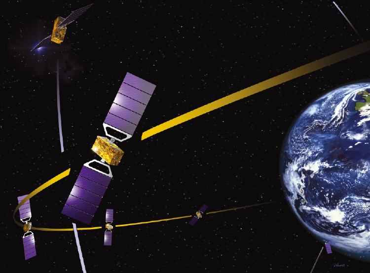
ESA artist conception of a Galileo NAVSAT above Earth. Click image for a larger view of a flotilla of Galileo satellites orbiting Earth.
When completed, the European system will rival the U.S. Global Positioning System (GPS) and the Russian GLObal NAvigation Satellite System (GLONASS). The GPS and Galileo networks, however, will be compatible.
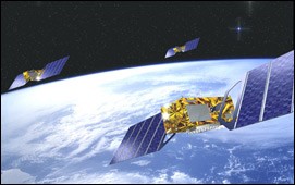
Galileo is the largest European space project to date with the eventual constellation of 30 satellites forming a global network providing precise timing and location information to users on the ground and in the air.
The first spacecraft in the system, named GIOVE A, was launched December 28, 2005, on a Russian Soyuz rocket from Russia's Baikonur Cosmodrome in Kazakhstan.
A second, named GIOVE B, will be sent up to orbit in Spring 2006. GIOVE stands for "Galileo In-Orbit Validation Element."
Together, they will demonstrate the atomic clock, navigation signals, and other technologies needed to run the global positioning system in orbit.
As test satellites, Giove-A and Giove-B will broadcast the first Galileo signals from space, but they won't be part of the final Galileo system.
Two more GIOVE satellites will be launched in 2008 to complete the testing phase. Four satellites must be in orbit for the system to deliver an exact position anywhere on earth.
Galileo service to the general public will start in 2009 when 12 satellites are in orbit.
The European Space Agency (ESA) expects to finish launching all 30 Galileo satellites in the system by 2010. The 30 will include 27 operational satellites and three active spares standing by as backups on orbit.
The Galileo constellation will fly in three circular, medium Earth orbit (MEO) planes 14,674 miles (23,616 km) above Earth.
Galileo navigation signals will be received at latitudes up to 75 degrees north, which covers the North Cape at the northern tip of Norway and Finland.
Memorial in space. GIOVE A carries a tribute to Tom Fairbairn, 25, a British space engineer who died in the tsunami on Boxing Day in 2005.
Fairbairn was killed during a holiday trip with his parents to Khao Lak in Thailand. A plaque on the side Giove-A is dedicated to Fairbairn.
Fairbairn had been employed on Giove's structural design team at the Surrey Satellite Technology Limited (SSTL) plant where the satellite was built in Guildford, Surrey, UK. The 200 employees of SSTL produce small satellites.
Why duplicate other GPS services? Like Europe's Ariane rockets and Airbus planes, the Galileo project has a political side designed to profess Europe's independence. Galileo is intended to guarantee the countries of the European Union – the EU, also known as Europa – access to their own GPS service.
European civilian authorities control the system, ending Europa's dependence on the U.S. military-controlled NAVSTAR Global Positioning System. Galileo, on the other hand, is a civilian program run by a private consortium with guaranteed service.
U.S. GPS signals can be degraded or even turned off by the Pentagon. As a service to civilians, GPS is free, but its continuity and quality can vary depending on military needs. Europeans say that means it is not completely reliable for applications such as landing planes or controlling trains.
The 25 member nations of the European Union are Austria, Belgium, Cyprus, Czech Republic, Denmark, Estonia, Finland, France, Germany, Greece, Hungary, Ireland, Italy, Latvia, Lithuania, Luxembourg, Malta, The Netherlands, Poland, Portugal, Slovakia, Slovenia, Spain, Sweden and the United Kingdom. In addition, Bulgaria, Croatia, Macedonia, Romania and Turkey are being considered for membership in the EU.
Several non-EU nations also will participate in the Galileo navsat program, including Argentina, China, India, Israel, Morocco, Norway, South Korea and Ukraine.
Major financial backers of Galileo are Germany, France, Italy and the UK.
Will it work better? ESA says Galileo will be more exact than GPS, finding locations within 3 feet (one meter) compared to 16 feet (five meters) with NAVSTAR GPS.
Galileo also will offer greater penetration in urban areas, inside buildings and under trees. It will improve coverage in northern Europe and other high-latitude areas.
The Galileo system will also come with an "integrity" component - it will be able to tell users if there are major errors that could compromise performance.
The European and American navigation satellite systems will be compatible. In the future, receivers will be able to find their locations using satellites in either constellation.
Consumers will be able to buy "Galileo-ready" receivers from 2008, although they won't be able to use the full Galileo network until 2010. From 2008, users will be able to switch back and forth between GPS and Galileo.
It is expected that there will be more than 400 million navigation satellite users by 2015. The United States is planning a new GPS generation with increased performance.
How satellite navigation works. Here's how users on the ground can find their locations:The atomic clocks aboard navigation satellites keep almost perfect time. They may lose a second in several thousand years.
- A Galileo or GPS device on or above the surface of Earth determines its position by receiving extremely-precise atomic-clock time signals transmitted by at least three of the navigation satellites and using those time signals to calculate the distance to each satellite.
- Altitude above the surface of Earth is added to the location by including in the calculation the time signal from a fourth satellite.
Galileo's clocks are ten times more precise than previous navsat clocks.
Search and rescue. Galileo also will function in the international search and rescue (SAR) network of satellites known as COSPAS-SARSAT.
ESA artist concept of a flotilla of European Galileo navsats above Earth
Each Galileo satellite will have a transponder capable of relaying distress signals received from lost users on the ground.
If it receives a signal from an emergency beacon on the ground, a Galileo satellite will alert a rescue coordination center on the ground, which will start a rescue operation.
Galileo also will transmit a signal back to the lost user on the ground, acknowledging his situation has been detected and that help is on the way.
Learn more: Galileo STO Galileo Europa Galileo ESA Galileo Industries Galileo Masters Challenge Surrey Satellite Technology Limited
GLONASS STO Russian Space Forces GLONASS
COSPAS-SARSAT Search and Rescue System NOAA Emergency Rescue Beacons NOAA
What is time? STO NAVSTAR Global Positioning System STO U.S. Coast Guard Navigation Center NAVSTAR GPS Operations U.S.Naval Observatory GPS Timing Operations U.S.Naval Observatory Global Positioning System Overview Univ of Colorado NAVSTAR GPS Fact Sheet U.S.Air Force GPS Garmin What is DGPS? National Geodetic Survey NOAA GPS Used to Track Birds STO Satellites Track Threatened Birds and Animals STO Satellite Wars Over Afghanistan and Yugoslavia STO GPS Internet Information Resources How GPS Receivers Work How Stuff Works GPS in a Wristwatch STO
Top of this page Satellites Search STO STO Cover Questions © 2006 Space Today Online