» February 29, 2004: Spirit inspected the surface of a rock named Humphrey with its microscope and alpha particle X-ray spectrometer. Then it used the wire-bristled brush of its rock abrasion tool to remove dust from three patches of the rock. Brushing three different places on a rock one right after another was an unprecedented use of the RAT. Then, Spirit rolled backward 2.8 feet and used its miniature thermal emission spectrometer to see what minerals were present on the cleaned areas. Next, the rock abrasion tool's diamond-toothed grinding wheel will cut into the rock to expose fresh interior material. The JPL team named the rock for Humphries Peak, the tallest mountain in Arizona and part of the San Francisco volcanic complex. Humphrey is about two feet tall and one of the largest blocks of what geologists suspect is material ejected from Bonneville Crater. It probably is a basaltic rock with fractures caused by the impact as it was hurled from the crater to its current resting place. Such rocks can give geologists a glimpse of what lies beneath the martian surface.
Picture: the rock Humphrey
» February 25, 2004: Spirit continues to photograph the sights around Middle Ground. In fact, it's recording a full panoramic picture of the surrounding area to identify scientifically interesting rocks. Spirit is about halfway to the rim of Bonneville Crater.
Picture: route map
» February 24, 2004: Spirit moved on to a new piece of turf the JPL team calls Middle Ground. Along the way, the rover paused to take snapshots of rocks on both sides of its path. The drive covered 98.4 feet, which was another one-day travel record for Spirit. The rover's auto-navigation software was controlling Spirit during the last 39.4 feet of the drive to Middle Ground when it noticed the slope into the hollow was steeper than desired. So, the rover then motored along the rim of the depression, looking for a safe way down. So far, it has been unable to locate a secure path into the crater. Altogether, Spirit has traversed 601.21 feet and now is some 443 feet from its original landing site, Columbia Memorial Station. Soon, the rover will drive down into Middle Ground to identify scientifically interesting rocks found there. Later, Spirit will resume its trek to the rim of Bonneville Crater, which is some 443 feet northeast of the rover's current location. Spirit is about halfway to the edge of Bonneville.
Illustration: 45-day path
» February 23, 2004: Spirit continued its inspection of the trench named Road Cut. It used the Mössbauer spectrometer, alpha particle X-ray spectrometer, microscope, and miniature thermal emission spectrometer – instruments on its robotic arm – to examine the subsurface soil exposed in the floor and walls of the trench as well as the rover's wheel tracks outside of the trench. Later, Spirit will resume its trek to the rim of Bonneville crater, which is some 443 feet northeast of the rover's current location.
» February 22, 2004: Spirit stuck its robot arm down into the trench it had dug into the floor of Laguna Hollow. It used the microscopic imager at the end of the arm to take pictures of details in the wall and floor of the trench. Then Spirit rotated the tool turret at the end of the arm and placed the Mössbauer spectrometer in position to read the mineral composition of the soil on the trench floor. After 12 hours, the rover switched instruments to the alpha particle X-ray spectrometer.
Picture: arm in the trench
» February 21, 2004: The JPL team gave the name Road Cut to the trench dug by Spirit.. It took Spirit two hours to dig the three-inch-deep trench with its left front wheel in the soil at Laguna Hollow. Because the ground at its location was harder, Spirit had to dig twice as long as Opportunity had at its location half way around the planet. Spirit had to scrape its wheel back and forth on the surface 11 times. Opportunityhad required only six. After it completed trenching, Spirit backed up 39 inches and analyzed the area with the miniature thermal emission spectrometer. Then it drove forward almost 16 inches and photographed the excavation with the panoramic camera. After another 16-inch move forward, Spirit took photos with the front hazard avoidance camera.
Picture: rover trenching
Next, the rover used its miniature thermal emission spectrometer to observe nearby rocks named Buffalo, Cherry, Cotton, and Jiminy Cricket. The rover used both the miniature thermal emission spectrometer and the panoramic camera to study a rock called Beacon. Then Spirit look down at its own deck with the panoramic camera to see what dust might have accumulated on the solar cells and the miniature thermal emission spectrometer calibration target.
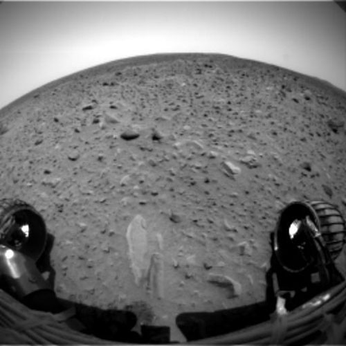
» February 20, 2004: Spirit is halfway through the 90-day period of its main assignment on Mars. Currently, the rover is examining the rim of a crater, photographing the surrounding soil with the panoramic camera and recording science data with the instruments on the end of its robot arm. Spirit snapped stereo microscopic pictures of undisturbed soil in Laguna Hollow, a shallow depression in the Gusev Crater.
Picture: undisturbed soil
The NASA JPL team controlling Spirit will command the rover to dig a trench at Laguna Hollow. Scientists want to know whether such a depression in the soil surface might have resulted from repeated swelling and shrinking of an upper layer of dirt covered with concentrated brine. Brine is water saturated with salt such as the ocean water on Earth. The scientists noticed that some of the soil in Laguna Hollow seemed to be sticking to Spirit's wheels. Could it be mud? The scientists don't know. Mud would be evidence of liquid water that might once have supported life.
Picture: Spirit tracks in Laguna Hollow
Pictures of the ground at Laguna Hollow also showed pebbles arranged in clusters or lines around lighter patches. Researcher called them "miniature hollows." They resembles patterns on the ground on Earth that result from alternating expansion and shrinkage of soil. Next, after it digs the trench, Spirit will continue on toward the rim of Bonneville Crater, about 443 feet away from the rover. Spirit has already driven 420 feet.
Picture: Laguna Hollow depression
Spirit also looked up through the atmosphere with its miniature thermal emission spectrometer at the same time that Mars Global Surveyor orbiter's thermal emission spectrometer was looking down through the same area of the atmosphere. Such concurrent observations will give scientists back on Earth a better understanding of the atmosphere above the surface of of Mars.
Illustration: rover communications
» February 19, 2004: Spirit continues on its way to the crater Bonneville. When its total distance traveled surpassed 354 feet, it had driven farther than the total distance traveled by the Mars Pathfinder rover Sojourner in 1997. Spirit is going to Bonneville because scientists think the impact that created the crater would have exposed whatever is beneath the rock layers in that area. Targets along the way to Bonneville included Halo and a circular depression dubbed Laguna Hollow. At Laguna Hollow, Spirit wiggled its wheels in the dirt to scuff the fine dust. It then recorded detailed observations with the instruments on the robotic arm. NASA JPL displayed an overhead photo showing Spirit's Path to Bonneville.
Illustration: the path to Bonneville
» February 16, 2004: Spirit contemplated its own wheel tracks in the martian soil, using the Mössbauer spectrometer. Then the rover retracted its robot arm and drove off on what the JPL team called a "mega drive" along the way to the crater Bonneville. Spirit drove 62.3 feet, rested, then drove another 27.9 feet for a total drive of 90.2 feet. That's another one-day-on-Mars record. The rover has about 800 feet to go to reach Bonneville. Along the way, it will do touch-and-go work at a place called Ramp Flats.
Picture: rock White Boat
» February 14, 2004: As it continued along the way toward the crater Bonneville, Spirit used its microscopic imager, Moessbauer spectrometer and alpha particle X-ray spectrometer to take a close look at the crest and trough of a drift formation it encountered. Then it backed away four inches, turned, and advanced four inches toward a flaky rock called Mimi, which is one of many features in the area known as Stone Council. Mimi looks different from other rocks seen so far in Gusev Crater. Could its flaky appearance mean the rock has been subjected to pressure through burial or impact? Could it mean the rock may once been a dune that was cemented into flaky layers by the action of water? After the rover checks out Mimi, it will resume its series of long daily drives toward the crater Bonneville seen on the northeastern horizon.
Picture: flaky rock Mimi
» February 13, 2004: On its way to a clump of rocks called Stone Council, Spirit broke its own driving record for the farthest distance driven in one day on Mars. The rover took 2 hours 48 minutes to travel 80 feet, reaching beyond its previous record of 69.6 feet. It recorded photos with its microscopic imager and panoramic camera. At Stone Council, Spirit will use the various science instruments on its robot arm, to study the soil and rocks. The rover is in the middle of an 810-ft. drive to the crater Bonneville.
Picture: the road ahead
Illustration: rover's road map
» February 11, 2004: Spirit broke the record for the farthest distance driven in one day on Mars. It traveled 69.6 feet, breaking the record of 23 feet set by the Pathfinder rover Sojourner back in 1997. Spirit is in the middle of an 810-ft. drive to the crater Bonneville. For the first time, Spirit used its autonomous navigation system to drive across what it sees as yellow and green colored terrain and avoid red terrain. While navigating its way to a rock named White Boat, the rover passed right over top of the rock Adirondack.
Picture: driving over Adirondack
Illustration: roving by color
» February 8, 2004: Spirit used its Mössbauer spectrometer, alpha particle X-ray spectrometer and microscopic imager to look closely at the interior of the rock Adirondack. The interior had been exposed when the rover's rock abrasion tool cut away the surface. Next, Spirit will drive south of its landing platform and then 270 yards northeast to a crater the JPL team calls Bonneville.
Picture: RAT hole in rock
» February 3, 2004: Engineers erased and reformatted Spirit's flash memory file system. Next, the rover will brush loose dust from the rock Adirondack so it can grind away with the rock abrasion tool (RAT) in search of clues to how that rock formed.
» February 2, 2004: Spirit brushed dust from the rock Adirondack with the rock abrasion tool – or RAT for short – on the end of its robotic arm. Then the rover used the microscope and two spectrometers at the end of the arm to examine the rock. Later, Spirit will grind the surface off of a small area of Adirondack with the RAT to reveal the rock's interior.
Picture: the RAT
Background: rover instruments
» February 1, 2004: Spirit's panoramic photos reveal two light-colored rocks, which the JPL team has nicknamed Cake and Blanco. The rover may drive over for a close-up look at them after it completes its work at the rock Adirondack.
Picture: Cake and Blanco Adirondack
Next, Spirit will drive 820 feet away to look at a crater named Bonneville. There, the rover will search for rocks excavated from below the surface and tossed out by the impact of whatever large object struck the planet and created the crater. If Spirit can reach the rim of the crater, it may be able to see outcrops in the crater walls.
NASA notes that, for the first time in history, two mobile robots are exploring the surface of another planet at the same time. Spirit hit the martian dirt on January 15 and its twin, Opportunity, made its first wheel tracks in the dirt on January 31. But what about those twin Viking landers back in 1976? Yes, they landed on Mars, but they were stationary. The Vikings weren't mobile rovers. Earth's first mobile robot explorer on Mars was Pathfinder's rover Sojourner in 1997.
Story: The Vikings
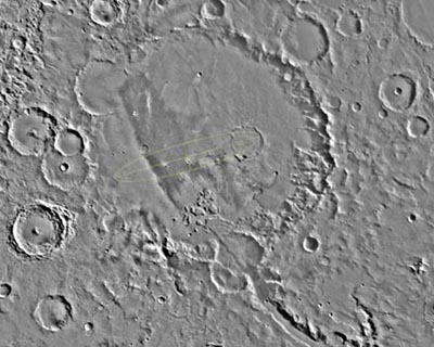
The giant bowl in the martian surface we call Gusev Crater probably was formed three or four billion years ago when an asteroid crashed into Mars between the planet's lowland northern plains and its southern highlands. Stretching 90 miles across an area similar in size to the state of Connecticut on Earth, the crater is about 1,900 miles southeast of the volcano Elysium Mons. People on Earth named the crater after the 19th century Russian astronomer Matvei Gusev.
Was Gusev Crater once a lake? If it were, how did it get water? A valley known as Ma'adim Vallis that connects into the south side of the crater probably was a river channel that poured water into the crater, forming a large lake. If so, the crater today should have a layer up to 3,000 feet thick of sediment that flowed in with the water. Other clues to a watery past would be deposits of minerals like gypsum or halite that form as water evaporates. Even if the bowl did hold water in ancient times, it's a dry lakebed today. Dust devils trail across the floor of the crater in recent satellite photos.
Photograph: Gusev Crater

|
» February 29, 2004: Opportunity used the microscopic imager at the tip of its robot arm to record eight images of the fine textures of an outcrop rock named Guadalupe. The rover also used its Moessbauer spectrometer and alpha particle X-ray spectrometer to check the composition of material exposed by grinding away the surface of Guadalupe with the rock abrasion tool. The rover drivers on the JPL team used a computer-generated visualization tool to plan Opportunity's best position for observing a layered rock named Last Chance on the far east end of the outcrop. They need to to position the rover's cameras at just the right distance from the rock in just the right sunlight. Planning is difficult because the uneven terrain underneath the rover could cause the camera tilt. When the picture is taken, all six rover wheels will be sitting on varied levels of rock and soil. The team wants pictures of two sides of the rock.
Illustration: planning at Last Chance
Opportunity photographed Charlie Flats, which is part of the bedrock outcropping at Meridiani Planum. The area has a diverse assortment of small grains, pebbles and spherules, as well as both dark and light soil deposits. The ground in the photo is about 2 feet across. The smallest visible grains are only a small fraction of an inch in size.
Picture: Charlie Flats
Opportunity used its panoramic camera to photograph the El Capitan region of the bedrock outcropping at Meridiani Planum. The bottom view is the Alpha waypoint station. The top view is the Bravo waypoint station.
Picture: El Capitan
» February 25, 2004: As Opportunity drives around the surface of Mars and uses its robotic arm, errors build up in its "attitude knowledge" of where it is. It needs an attitude adjustment about once a week or after driving long distances. To correct those subtle changes in its attitude knowledge, the JPL engineers tell the rover to point its panoramic camera at the Sun as it travels across the martian sky for 15 minutes. Opportunity then uses what it sees in the Sun's movement to calculate its own exact location and position on Mars. Such an attitude adjustment helps the rover point its science instruments precisely at particular rocks and patches of soil. It also allows the rover to point the high gain antenna accurately toward Earth, which improves communication with the NASA JPL team. The rover is at El Capitan, a large outcropping of bedrock in the crater where the rover landed. El Capitan itself is within a larger bedrock outcropping named Opportunity Ledge. Opportunity transmitted a very large byte of data to Earth via the orbiting satellites Mars Global Surveyor and Mars Odyssey. The package of information relayed home by the Mars Odyssey alone was a whopping 145.6 megabits of data. The rover had been using its alpha particle X-ray spectrometer, miniature thermal emission spectrometer, and Moessbauer spectrometer to sniff around inside the hole it had dug with the abrasion tool in the rock McKittrick Middle Rat at El Capitan. A microscopic image showed a semi-circular depression that resulted from Opportunity's grinding of the rock with its abrasion tool. The tool, known as RAT, sliced about 0.16 inches into the surface of the rock and ground off a patch 1.8 inches across. Exposed inside was a spherical feature that the JPL team called a "blueberry." It had been cut in half within the rock. In the bottom right of the picture, it looked like it had been scratched by the rover's grinding wheel.
Picture: blueberry
» February 24, 2004: The JPL team was ecstatic after Opportunity completed its first abrasion tool operation on a rock known as McKittrick Middle Rat at the El Capitan site inside the crater. The rock abrasion tool shaved the rock for two hours, grinding to a total depth of about 0.16 inches. Another abrasion tool target in the same area is the rock Guadalupe. The rover has been doing a lot of science work at night, and the season on Mars is changing to winter, so the rover has less energy to work with than it did earlier in the mission. The martian days are getting shorter and the sun angle is not striking either of the rovers' solar panels as much as in the past. Thus, Opportunity needs to rest more often to recharge its batteries. The rover is at El Capitan, the curb-sized outcrop in the crater where the rover landed. El Capitan is located within a larger bedrock outcropping named Opportunity Ledge.
Picture: Opportunity at El Capitan
» February 23, 2004: Opportunity inspected El Capitan, which is part of the street-curb-sized outcrop in the crater where the rover landed. El Capitan is located within a larger bedrock outcropping named Opportunity Ledge. Opportunity took 46 pictures with its microscope, then placed its Mössbauer spectrometer and alpha particle X-ray spectrometer on the rock to assess what minerals and elements are in it. Next, Opportunity will use its rock abrasion tool to grind away the surface of El Capitan. That will be the first use of the RAT by Opportunity.
Illustration: RAT target at El Capitan
» February 21, 2004: Opportunity drove 50 feet from the trench to the El Capitan. As the rover skirted the trench and avoided the lander, the drive was Opportunity's longest so far. It used the panoramic camera, miniature thermal emission spectrometer, and microscopic imager to record mineralogy and geology data on the area around El Capitan. The site is interesting because it has varying textures and layers of dirt and rock.
» February 20, 2004: Opportunity took a close look inside the hole it dug in the martian soil and found shiny, spherical objects embedded within the trench wall. The spheres stood out in a photo by the microscopic imager on the rover's robot arm. The area in the spheres picture is about 1.2 inches across.
Picture: shiny spheres
A different microscopic imager photo reveals the clodding or cementation of the sand grains within the trench wall. Scientists say it reminds them of a stucco wall. The area in this image measures about 1.2 inches across. The entire trench is 20 inches long by 8 inches wide and 4 inches deep. It shows clods of soil in its upper wall and the bright soil in its bottom.
Picture: stucco wall
Yet another microscopic imager photograph shows smaller grains of soil mixed with larger pebbles. The area in the picture also is about 1.2 inches across. Next, Opportunity will drive 30 feet to the El Capitan area of the bedrock outcropping. The rover will stop 6 feet short of El Capitan to take images with its panoramic camera and gather science measurements with its miniature thermal emission spectrometer. Then, it will move in to use the rock abrasion tool and other instruments on an El Capitan rock.
Picture: pebbles and soil grains
» February 19, 2004: Opportunity scooped out the trench with one of its wheels, as planned, to reveal what lies beneath the surface of a patch of soil. Scientists chose to dig at that particular spot because data from the rover's miniature thermal emission spectrometer suggested it contains the mineral crystalline hematite that sometimes forms in water. To dig, Opportunity pushed soil back and forth out of the trench for 22 minutes with its right front wheel while other wheels held the rover in place. The trench is 20 inches long by 8 inches wide and 4 inches deep. Scientists immediately noticed clotty soil in the upper wall of the trench and the bright soil in the bottom. It's not clear whether the brightness is the natural color of the soil or a reflection of the Sun. Opportunity also looked down at its right front wheel to see what, if anything, stuck there during the trenching activity.
Picture: the trench
» February 16, 2004: Opportunity arrived at the spot chosen for it to dig a ditch. The rover examined the trenching site with its microscopic imager, Mössbauer spectrometer and alpha particle X-ray spectrometer. The trench will be made by alternating forward and backward spinning of the rover's right front wheel. Then, Opportunity will take a look down in the resulting hole to see what's below the surface. Meanwhile, the rover looked up at the atmosphere just as the orbiter Mars Global Surveyor was flying by overhead. Opportunity and Mars Global Surveyor have similar infrared sensing instruments – a miniature thermal emission spectrometer on the rover and a full-size thermal emission spectrometer on the orbiter. By coordinating their observations of the atmosphere – with one looking down through the atmosphere and the other looking up – they can send home to Earth a more complete atmospheric profile than either could do alone.
Picture: u-turn wheel tracks
» February 14, 2004: Opportunity said "no" to mission controllers back on Earth. They had sent commands asking the rover to use the microscopic imager at the end of its robot arm. Opportunity's computer judged the requested arm movement to be unacceptable and properly refused the command. Engineers on the NASA JPL team in California figured out different, acceptable motions for the rover's arm. Observations by the panoramic camera and miniature thermal emission spectrometer were completed as the rover continues its drive to the site where it will conduct soil examination and trenching. Geologists back on Earth are using a hematite abundance map to navigate Opportunity to hematite-rich locations. On the map, red dots mark areas high in hematite and blue dots show areas low in hematite.
Illustration: hematite abundance map
» February 13, 2004: Scientists back home at NASA JPL are peering at Opportunity photos that show what look a bit like berries on the ground in front of the rover. The objects in the extreme close-up are round formations in the martian soil near the Stone Mountain rock outcrop. Scientists wonder if the curious blobs are clues to the past environmental conditions in that area of Mars. The image is one of the highest resolution images ever taken by the microscopic imager at the end of the rover's robot arm.
Picture: Berries on the ground
Meanwhile, Opportunity climbed to Waypoint Charlie to complete its survey of the so-called Opportunity Ledge rock outcropping. The rover conducted a touch-and-go examination of the soil around Waypoint Charlie, then retracted its the arm and drove off toward a spot where the rover's miniature thermal emission spectrometer indicates the soil is rich in hematite. There, Opportunity will spin one of its wheels to dig a trench in the soil. Scientists on Earth will use photos sent back by the rover to peer into that shallow hole to see what is beneath the surface of the martian dirt. Information on the distribution of hematite on Mars should help scientists understand the planet's past environment, which might suiggest whetherr the environment was favorable for life to evolve there. Later, the rover will drive back along Opportunity Ledge to the most interesting science locations.
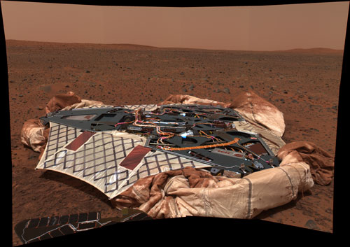
» February 11, 2004: Opportunity may have slipped a bit on the loose martian soil as it drove 12 feet along the bedrock outcropping. The JPL team has a "shoot and scoot" itinerary for the rover, meaning Opportunity will shoot close-up photos and record scientific measurements of the rocks, then scoot up and along the ledge of the crater. Meanwhile, the rover also looked back to snap a picture of its landing platform and parachute.
Picture: platform and parachute
Picture: Stone Mountain
Picture: Stone Mountain close-up
» February 8, 2004: At Stone Mountain, Opportunity took microscopic images of a rock called Robert E in the outcrop as well as nearby soil. Robert E also was examined with the alpha particle X-ray spectrometer and the Mössbauer spectrometer. The rover used its panoramic and navigation cameras to photograph the bedrock outcropping. Next, Opportunity will drive along the outcrop investigating points along the way.
Photos: driving to Stone Mountain
Photos: driving away from the lander
» February 7, 2004: In a so-called touch-and-go maneuver, Opportunity reached down with its robot arm and took microscopic images of the soil. The panoramic camera and the miniature thermal emission spectrometer also made observations. The rover then retracted its arm and drove on to Stone Mountain, a rock outcrop previously nicknamed Snout.
Picture: Mars soil
» February 3, 2004: Opportunity completed its 24-hour observation of the soil near the landing platform using the Mössbauer spectrometer on the Tarmac soil patch. The rover's robot arm pushed the alpha particle X-ray spectrometer onto the same patch of soil for additional observations. Spherical grains were seen through the microscopic imager. Next, the arm will be stowed and the rover will drive ten feet to the right end of the bedrock outcropping where it will trench the soil.
» February 2, 2004: Opportunity extended its robot arm and engineers confirmed all instruments at the end of the rover's arm are working. Each of NASA's two Mars rovers has an arm for positioning tools at targets for examination on the Red Planet.
Picture: Opportunity's Arm
Next, Opportunity will use two of the instruments on the arm to examine a patch of soil in front of the rover. A microscope on the arm will reveal structures as thin as a human hair and a Mössbauer Spectrometer will identify minerals in the soil. Then, the rover will turn the turret at the end of the arm in order to examine the same patch of soil with the alpha particle X-ray spectrometer, revealing chemical elements.
Picture: Mössbauer Spectrometer
Picture: Alpha Particle X-ray Spectrometer
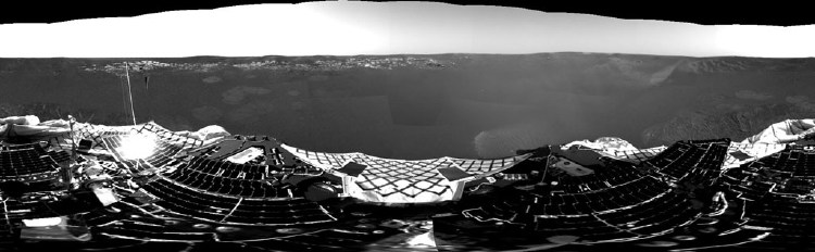
Opportunity completed a 360-degree color panorama showing a trail of bounce marks down the inner slope of the small crater where the spacecraft came to rest when it landed on Mars.
Picture: Opportunity's panorama
» February 1, 2004: The crater floor surrounding Opportunity is covered with gray granules containing hematite. In fact, the idea that the mineral hematite existed on Meridiani Planum was the principal reason the site was selected by NASA for exploration. The rover's Miniature Thermal Emission Spectrometer (Mini-TES) has confirmed the presence of crystalline hematite. On Earth, crystalline hematite usually forms in a wet environment. On Mars, in the wall of Opportunity's crater, there is a concentration of hematite in a layer of dark material above a light-covered outcrop. Beyond the crater, the martian surface may be rich in hematite.
Both of the Mars exploration rovers have Mini-TES instruments, which are infrared-sensing tools for identifying rock types from a distance. All warm objects emit heat. Mini-TES determines the mineralogy of rocks and soil from a distance by detecting their patterns of thermal radiation. Mini-TES, provided by Arizona State University, has the job of identifying promising objects for examination and for determining how martian rocks were formed. The instrument also can look up at the Martian sky to provide temperature profiles of the atmosphere. Mini-TESS is inside Spirit's body in the so-called Warm Electronics Box, a heated container that insulates sensitive electronic equipment from the temperature extremes on the martian surface. Similar TESS instruments are aboard the Mars Global Surveyor and the Mars Odyssey orbiters.
Picture: Mini-TES
Opportunity's landing site, Meridiani Planum, is part of Terra Meridiani, a large area near the equator. But what does Meridiani Planum mean? The Latin word meridiani indicates the meridian of the planet Mars, the line at zero degrees longitude, passes through the area. The Latin word planum means plain. Thus, Opportunity landed in a crater on the meridian plain near the equator.
Next, Opportunity will begin to send to Earth its microscopic images and spectrometer readings of the soil close to the lander. After that, the rover will drive northwest about 26 feet to an outcrop of bedrock.
Picture: Opportunity wheel tracks
|


